Geosilicon has provided Digital photogrammetric solutions with technically skilled team in across India. A lot of changes have occurred since this time and we have been a key driver of new technology. Our derived products go through a barrage of quality control procedures designed to ensure a good product. All Digital photogrammetry services are performed using the most advanced softcopy workstations operating the latest proven software tools.
Orthorectification is the process of removing the distortion within an image caused by terrain relief and the camera. This is done by modeling the nature and magnitude of geometric distortions in the imagery. Camera or satellite models in conjunction with limited ground control, allow construction of correction formulae that produce accurate, geometrically correct, map-oriented imagery.
Geosilicon offers various options of terrain datasets for orthorectification. The choice of DTM used for this process depends upon customers accuracy requirements.
The company has extensive experience in providing data that has applications in the following areas:
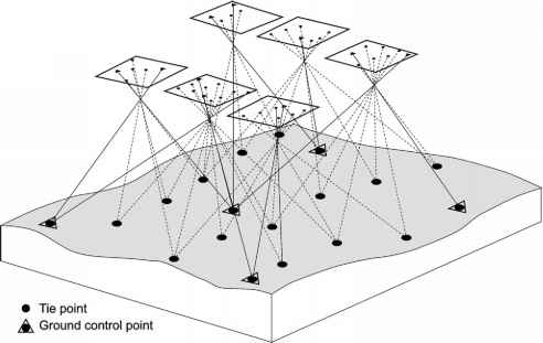
Aerial Triangulation in Photogrammetry is the method of determining and calculating 3-dimensional object coordinates by photogrammetric means,by using photographs exposed from different positions, covering the same object.
Digital Elevation Models (DEM)
A digital elevation model is a regularly-spaced bare-earth raster grid referenced to a common vertical datum. When you filter out non-ground points such as bridges and roads, you are left with a smooth digital elevation model.
Digital Surface Models (DSM)
DSM measures the height values of the first surface on the ground. This includes terrain features, buildings, vegetation and power lines etc. DSM therefore provides a topographic model of the earth's surface.
Digital Terrain Models (DTM)
Digital Terrain Modelling (DTM) is the collection of mass points of elevations and 3D breaklines at each change of terrain using Summit Evolution softcopy workstations.
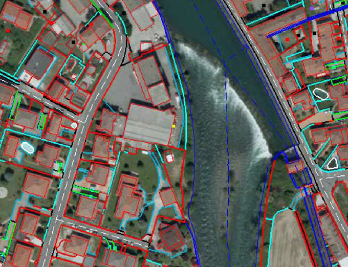
Planimetric Mapping
Planimetric maps develops natural features with their exact coordinate locations. These features are comprised of vegetation, trails, fences, utility poles, drainage systems, driveways, road boundaries and curbs.
Topographic Mapping
Topographic maps are detailed, accurate graphic representations of features that appear on the Earth's surface. These features include:
Contour Generation
Contours are commonly in vector formats (e.g., shape file, dxf) and derived from a reconstructed TIN of DEM . Contours are among the most commonly used representations for elevations.
3-D Feature Extraction/Elevations
We provide accurate digital planimetric feature extraction for cartography mapping and 3D topo mapping in industry accepted standard formats.
Change Detection
Timely and accurate change detection of Earth's surface features is extremely important for understanding relationships and interactions between human and natural phenomena in order to promote better decision making. Remote sensing data are primary sources extensively used for change detection in recent decades.